
Situated at a height of 410 m in the famous Mount. Namafjall, this pass has managed to derive its name based on the 19th century due to sulfur recovery from this mountain. One of the best ways to reach to the famous pass certainly is to try and take route No. 1 of the Ring road that is located between the Mynav and the Egilssta. There is also another route which is called as the Serpentine routes which you can take from the Reykjahli, that is situated at least 5 Kms away. Lake Myvatn is one place that is also looked up as most famous resort area of Iceland and can be reached just within 45 minutes from the nearest town. So, once you have managed to reach Hinauffahrt, you may immediately get a nice view of the Muckensee and the Jar-ba-sholar, which is also a famous volcanic crater and covers the Jar-bo-in lagoon right behind it.


Richat Structure, Gurun Sahara ~ Bermata Lembu
This prominent circular feature, known as the Richat Structure, in the Sahara desert of Mauritania is often noted by astronauts because it forms a conspicuous 50-kilometer-wide (30-mile-wide) bull’s-eye on the otherwise rather featureless expanse of the desert. Initially mistaken for a possible impact crater, it is now known to be an eroded circular anticline (structural dome) of layered sedimentary rocks.
Extensive sand dunes occur in this region and the interaction of bedrock topography, wind, and moving sand is evident in this scene. Note especially how the dune field ends abruptly short of the cliffs at the far right as wind from the northeast (lower right) apparently funnels around the cliff point, sweeping clean areas near the base of the cliff. Note also the small isolated peak within the dune field. That peak captures some sand on its windward side, but mostly deflects the wind and sand around its sides, creating a sand-barren streak that continues far downwind.


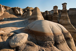
The word Bisti (actually up-ta-hie ) is from the language of the Navajo Indians and means as bad country (English Badlands). And indeed, at first sight, one could really come to this conclusion. The landscape is barren, dominated by myriad colored clay hills and almost completely without vegetation. Apart from a few tufts of grass growing here and no nothing. In no area I know the expression matches moon landscape better than theBisti Badlands . Everywhere you can find the most remarkable structures of stone and clay, and nowhere more than here hoodoos. Instinctively one feels in the primeval Earth back who, when even the dinosaurs populated the planet. Fossils of all kinds can be seen here, but mainly petrified wood.With luck, you will even find fossilized bones. Wandering through the Bisti'slandscape is a rapidly aware of the uniqueness. By the absolute silence and seclusion, this impression is also reinforced. Even if one or two cars are at the trailhead, we will take out almost anyone here. The area is just too big and the many hills quite complex. The whole area is rich in mineral resources, especially fossil fuels. The coal here is often directly at the surface. In many places undergo several meters thick black layers of the colored badlands . Fortunately, at least a portion of the region (18,000 ha) as Bisti / De-Na-Zin Wilderness under protection, so that a commercial use is expressly prohibited now. (Currently) only a few people find their way to this region, as the visitor flow can not be over-regulated and permits.
Before I finish the general part and I dedicate the actual trips, even a few words regarding the pronunciation of the word Bisti Wilderness . Language's genius will probably know me that's new: The word wilderness , in contrast to the adjective wild , non W an lderness , but W i lderness pronounced. InBisti are the ghosts: Are i or Are an even though it on the official BLM site very clear Are egg is called. Who wants to be sure it speaks Indian (see above) and is therefore probably correct.
Source: http://www.synnatschke.de/bisti/bisti.html


No comments:
Post a Comment